Heu oblidat la contrasenya? Nou usuari? Registrar
Whale Shark, Philippines. Photo by Stephane Rochon.
Gaudiu i participeu!
| Trobeu els millors llocs d'immersió |
|
|
 Pinar 1
Turkey, Aegean, Bodrum
Aquest és un mapa interactiu! Empreu els controls per desplaçar i ampliar aquest mapa.
|
Datum: WGS84 [ Ajuda ] |
Latitud: 36° 58.08' N |
Valoració dels usuaris (0)
- Favorit
-
Les vostres llistes de favorits i de futurs llocs d'immersió
Accés
|
English (Traduiu aquest text en Català): Black island Com? En barca Distància Poc temps de barca (< 30 minuts) Fàcil de trobar? Fàcil de trobar |
Característiques del lloc d'immersió
Nom alternatiu Black island
Profunditat mitjana 15 m / 49.2 ft
profunditat màxima 40 m / 131.2 ft
Corrent Fluix ( < 1 nus)
Visibilitat Bona ( 10 - 30 m)
Qualitat
Qualitat del lloc d'immersió Bé
Experiència CMAS * / OW
Interès biològic Interessant
Més detalls
Gentada entre setmana
Gentada al cap de setmana
Tipus d'immersió
- Escull
Activitats del lloc d'immersió
- Fotografia
Perills
Informació addicional
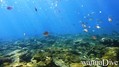
English (Traduiu aquest text en Català): Many amphorae, groupers, nudibranchs
Autor: ysylon Col·laboradors (1) Han fet immersió en aquest lloc ! (8)
 Comentaris
Per markfldavison , 31-08-2009
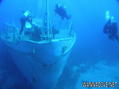
Pinar - Turkish Naval Tanker Pinar This wreck was sunk 4 on the 20 May 2007. The small Tanker has a length of 37m and a beam of 7m and displaced 500 ton. The Pinar was built in 1938 and commissioned into the Turkish Navy in 1939. Clearly the Turkish Navy gets value for money from their investments! Again the engines were removed along with all hazardous materials, prior to sinking. The highest point of the wreck is 15m most of the deck is 20 - 25m with the bow sitting at 35m. The wheelhouse can be entered by suitably qualified and experienced divers
Errors, comentaris
Podeu editar aquesta pàgina per corregir errors o afegir nova informació. Si teniu cap problema en relació a aquesta pàgina, Envieu comentaris.