Aquest és un mapa interactiu! Empreu els controls per desplaçar i ampliar aquest mapa.
Valoració dels usuaris (0)
Accés
|
English (Traduiu aquest text en Català): Access from route 655 from øye in too the mountain
English (Traduiu aquest text en Català): Access from route 655 from øye in too the mountain
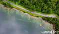
Access from route 655 from øye in too the mountain
English (Traduiu aquest text en Català): Access from route 655 from øye in too the mountain
English (Traduiu aquest text en Català): Access from route 655 from øye in too the mountain
English (Traduiu aquest text en Català): Access from route 655 from øye in too the mountain
English (Traduiu aquest text en Català): Access from route 655 from øye in too the mountain
English (Traduiu aquest text en Català): Access from route 655 from øye in too the mountain
English (Traduiu aquest text en Català): Access from route 655 from øye in too the mountain
Com? Des de la costa
Distància Accés immediat
Fàcil de trobar? Fàcil de trobar
|
|
Característiques del lloc d'immersió
Nom alternatiu Civilizatione lost
Profunditat mitjana 10 m / 32.8 ft
profunditat màxima 18 m / 59.1 ft
Corrent Cap
Visibilitat Bona ( 10 - 30 m)
Qualitat
Qualitat del lloc d'immersió Molt bé
Experiència CMAS * / OW
Interès biològic Cap
Més detalls
Gentada entre setmana
Gentada al cap de setmana
Tipus d'immersió
- Aigua dolça
Activitats del lloc d'immersió
- Immersió nocturna
- Snorkel / immersió a pulmó
- Fotografia
- Pràctica d'immersió
Perills
Informació addicional
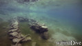
English (Traduiu aquest text en Català): A small village that was flooded after a rock slide that blocked the river that flows down the valley and formed an artificial lake and flooded a farm that still stands as one can see today
The lake is at an altitude of ca 200 meter's above sea level
English (Traduiu aquest text en Català): A small village that was flooded after a rock slide that blocked the river that flows down the valley and formed an artificial lake and flooded a farm that still stands as one can see today
The lake is at an altitude of ca 200 meter's above sea level
A small village that was flooded after a rock slide that blocked the river that flows down the valley and formed an artificial lake and flooded a farm that still stands as one can see today
The lake is at an altitude of ca 200 meter's above sea level
English (Traduiu aquest text en Català): A small village that was flooded after a rock slide that blocked the river that flows down the valley and formed an artificial lake and flooded a farm that still stands as one can see today
The lake is at an altitude of ca 200 meter's above sea level
English (Traduiu aquest text en Català): A small village that was flooded after a rock slide that blocked the river that flows down the valley and formed an artificial lake and flooded a farm that still stands as one can see today
The lake is at an altitude of ca 200 meter's above sea level
English (Traduiu aquest text en Català): A small village that was flooded after a rock slide that blocked the river that flows down the valley and formed an artificial lake and flooded a farm that still stands as one can see today
The lake is at an altitude of ca 200 meter's above sea level
English (Traduiu aquest text en Català): A small village that was flooded after a rock slide that blocked the river that flows down the valley and formed an artificial lake and flooded a farm that still stands as one can see today
The lake is at an altitude of ca 200 meter's above sea level
English (Traduiu aquest text en Català): A small village that was flooded after a rock slide that blocked the river that flows down the valley and formed an artificial lake and flooded a farm that still stands as one can see today
The lake is at an altitude of ca 200 meter's above sea level
English (Traduiu aquest text en Català): A small village that was flooded after a rock slide that blocked the river that flows down the valley and formed an artificial lake and flooded a farm that still stands as one can see today
The lake is at an altitude of ca 200 meter's above sea level
 Comentaris
Mostrar tot (0)...
Sigueu el primer a comentar aquest país
Errors, comentaris
Podeu editar aquesta pàgina per corregir errors o afegir nova informació. Si teniu cap problema en relació a aquesta pàgina, Envieu comentaris.
Wannadive.net 24/24
Wannadive.net al teu mòbil

Butlletí Totes les notícies per correu electrònic
 Lyngstølsvatnet