Heu oblidat la contrasenya? Nou usuari? Registrar
Clownfish, Philippines. Photo by Stephane Rochon.
Gaudiu i participeu!
| Trobeu els millors llocs d'immersió |
|
|
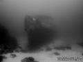
 Imperial Eagle MV
Malta, Malta island
Aquest és un mapa interactiu! Empreu els controls per desplaçar i ampliar aquest mapa.
|
Datum: WGS84 [ Ajuda ] |
Latitud: 35° 57.096' N |
Valoració dels usuaris (1)
- Favorit
-
Les vostres llistes de favorits i de futurs llocs d'immersió
Accés
|
Com? En barca Distància Poc temps de barca (< 30 minuts) Fàcil de trobar? Fàcil de trobar |
Característiques del lloc d'immersió
Nom alternatiu Imperial Eagle ferry
Profunditat mitjana 35 m / 114.8 ft
profunditat màxima 46 m / 150.9 ft
Corrent Fluix ( < 1 nus)
Visibilitat Bona ( 10 - 30 m)
Qualitat
Qualitat del lloc d'immersió Molt bé
Experiència CMAS ** / AOW
Interès biològic Interessant
Més detalls
Gentada entre setmana
Gentada al cap de setmana
Tipus d'immersió
- Derelicte
Activitats del lloc d'immersió
- Formació de busseig
- Fotografia
Perills
- Profunditat
Informació addicional
English (Traduiu aquest text en Català): The Imperial Eagle was one of the ferryboats connecting Malta and Gozo.
The hull, in navigation trim, lays on a sandy bottom at a depth of -42m, 300m North-East of Qwara Point.
Autor: Vladimir Dunaev Col·laboradors (1) Han fet immersió en aquest lloc ! (6)
 Fotos
Fotos

Imperial Eagle MV |

Imperial Eagle MV |

Imperial Eagle MV |
Imperial Eagle MV |
Comentaris
Sigueu el primer a comentar aquest país
Errors, comentaris
Podeu editar aquesta pàgina per corregir errors o afegir nova informació. Si teniu cap problema en relació a aquesta pàgina, Envieu comentaris.