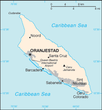
Aruba is a 33-kilometre (21 mi)-long island of the Lesser Antilles in the southern Caribbean Sea, 27 km (17 mi) north of the Paraguaná Peninsula, Falcón State, Venezuela. It is part of the Kingdom of the Netherlands. As a separate member state of the Kingdom of the Netherlands, Aruba has no administrative subdivisions. Unlike much of the Caribbean region, Aruba has a dry climate and an arid, cactus-strewn landscape. This climate has helped tourism as visitors to the island can reliably expect warm sunny weather. It has a land area of 193 km² (75 sq mi) and lies outside the hurricane belt.
Localització: Caribbean, island in the Caribbean Sea, north of Venezuela
Coordenades geogràfiques: 12° 30' N, 69° 58' W
Km de costa: 68.5 km km
Clima: tropical marine; little seasonal temperature variation
Terreny: flat with a few hills; scant vegetation
Elevació: lowest point: Caribbean Sea 0 m
highest point: Mount Jamanota 188 m
Perills naturals: lies outside the Caribbean hurricane belt
Moneda: Aruban guilder/florin (AWG)
Població: 71,891 (July 2006 est.)
Idiomes: Dutch (official), Papiamento (a Spanish, Portuguese, Dutch, English dialect), English (widely spoken), Spanish
Capital: Oranjestad
Divisions: none (part of the Kingdom of the Netherlands)
Mapa addicional
Aquest és un mapa interactiu! Empreu els controls per desplaçar i ampliar aquest mapa.
El vostre lloc d'immersió favorit no és a la llista? Afegiu un lloc d'immersió
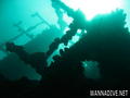
Llocs d'immersió
 Comentaris
Mostrar tot (3)...
Errors, comentaris
Si voleu afegir nova informació o heu trobat errors sobre aquest país, Envieu comentaris.
Wannadive.net 24/24
Wannadive.net al teu mòbil

Butlletí Totes les notícies per correu electrònic
 Aruba
Aruba