Gaudiu i participeu!
| Trobeu els millors llocs d'immersió |
|
|
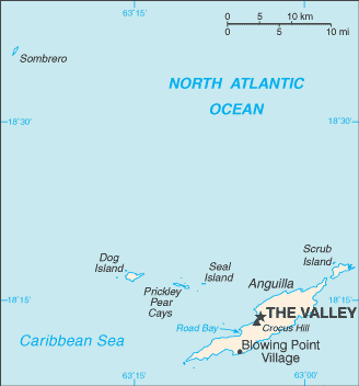
 Anguilla
Amèrica Central
Localització: Caribbean, islands between the Caribbean Sea and North Atlantic Ocean, east of Puerto Rico
Coordenades geogràfiques: 18° 15' N, 63° 10' W
Km de costa: 61 km km
Clima: tropical; moderated by northeast trade winds
Terreny: flat and low-lying island of coral and limestone
Elevació: lowest point: Caribbean Sea 0 m
highest point: Crocus Hill 65 m
Perills naturals: frequent hurricanes and other tropical storms (July to October)
Moneda: East Caribbean dollar (XCD)
Població: 13,677 (July 2007 est.)
Idiomes: English (official)
Capital: The Valley
Divisions: none (overseas territory of the UK)
Més detalls
| Jan | Feb | Mar | Apr | May | Jun | Jul | Aug | Sep | Oct | Nov | Dec | |
|---|---|---|---|---|---|---|---|---|---|---|---|---|
| Climate | ||||||||||||
| Air temp. | ||||||||||||
| Water temp. | ||||||||||||
| Equipment | ||||||||||||
| Best season | 
|

|

|

|

|

|

|

|

|

|

|

|
Mapa addicional

Voleu afegir alguna informació sobre Anguilla? Feu-nos-ho saber...
Aquest és un mapa interactiu! Empreu els controls per desplaçar i ampliar aquest mapa.
- registres d'immersió (76)
- viatges (10)
- Fotos (1)
- Vídeos (0)
- Favorit
-
Les vostres llistes de favorits i de futurs llocs d'immersió
Llocs d'immersió
| Llocs d'immersió (21) | Qualitat | Profunditat mitjana | Profunditat màxima | Experiència | Tipus d'immersió | ||
|---|---|---|---|---|---|---|---|
| Angel Reef | - / - | 49.2 ft | 65 ft | Tots els submarinistes | 
|
||
| Anguillita | - / - | 35.1 ft | 60 ft | CMAS * / OW | 

|
||
| Beacon | - / - | 49.2 ft | 69.9 ft | Tots els submarinistes | 
|
||
| Blowing Rock | - / - | 29.9 ft | 40 ft | Tots els submarinistes | 


|
||
| Captain Turtle | - / - | 49.2 ft | 65 ft | Tots els submarinistes | 
|
||
| Crystal Reef | - / - | 54.1 ft | 82 ft | CMAS * / OW | 
|
||
| Dog Island | - / - | 65.6 ft | 100.1 ft | CMAS ** / AOW | 


|
||
| Frenchman's Reef | - / - | 65.6 ft | 100.1 ft | CMAS * / OW | 
|
||
| Lobster Reef | - / - | 59.1 ft | 100.1 ft | Tots els submarinistes | 
|
||
| MV Catheley H Wreck | - / - | 35.1 ft | 60 ft | Tots els submarinistes | 
|
||
| MV Commerce | - / - | 65.6 ft | 82 ft | CMAS * / OW | 

|
||
| MV Ida Maria Wreck | - / - | 40 ft | 60 ft | CMAS * / OW | 
|
||
| MV Oosterdiep | - / - | 80.1 ft | 82 ft | Tots els submarinistes | 
|
||
| MV Sarah | - / - | 65.6 ft | 85 ft | CMAS * / OW | 

|
||
| No Name Reef | 1 / - | 40 ft | 55.1 ft | Tots els submarinistes | 
|
||
| Prickly Pear | - / - | 16.4 ft | 55.8 ft | Tots els submarinistes | 
|
||
| Sea Fan | - / - | 32.8 ft | 40 ft | Tots els submarinistes | 
|
||
| Shoal Bay Reef | - / - | 59.1 ft | 85 ft | Tots els submarinistes | 
|
||
| Teigland | - / - | 49.2 ft | 68.9 ft | Tots els submarinistes | 
|
||
| The Garden | - / - | 82 ft | 111.9 ft | CMAS * / OW | 
|
||
| West Cay | - / - | 49.2 ft | 105 ft | CMAS * / OW | 

|
 Registres d'immersions
|
 Viatges de busseig
|
 Comentaris
Errors, comentaris
Si voleu afegir nova informació o heu trobat errors sobre aquest país, Envieu comentaris.


